
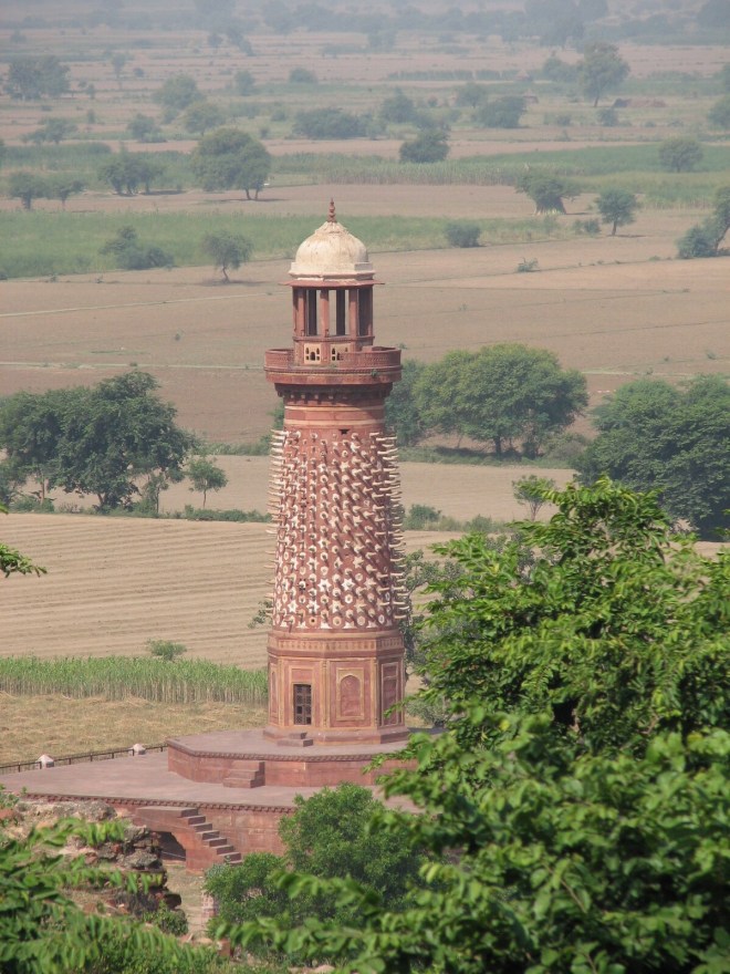
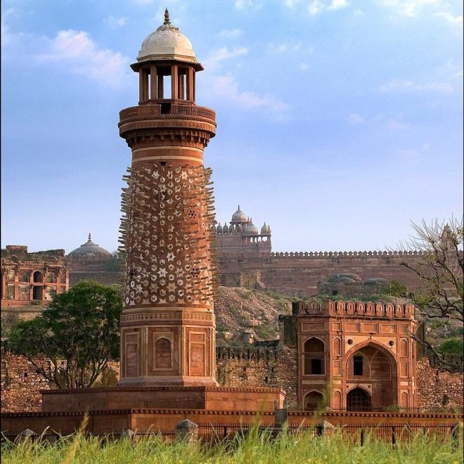
One of the iconic images related with Fathpur Sikri is the Hiran Minar, which in popular legend is a tower embedded with elephant tusks. According to some legends Akbar would sit on its top as elephant fights would take place below. According to another version, the emperor would watch the polo matches being played in the Chaughāngāh (Polo-Ground) stretching besides the lake.
At the present moment this tower stands forlorn between the Hāthīpol (the Elephant Gate) and the dry bed of the lake which had now turned to fields.

To understand this tower and its purpose, one would have to understand the layout plan of the city and it’s inspirations, the sources of urban design.
Mughal Encampment
One of the major sources of Mughal urban design was the mobile Mughal Encampment which has been described not only by Abu’l Fazl but a number of European travellers accounts as well. The Mughals, the other Timurids before them were peripatetic by nature: they would be constantly on the move and would seldom stay for long at a place. For instance, Amīr Timur, who created the magnificent palaces at Samarkand, whenever in the city, would never stay in his creations, but would live mostly in tents fixed in the gardens laid out outside the city. At other times, he would be travelling with his entourage from one corner of his empire to another. This same practice was followed by Babur and his successors in India.

Camp on the move was no small entourage but a whole city on the move: along with the Emperor were his nobles, bureaucrats and retainers. Each had their own personal service men. Then there were those who came to meet the king or the nobles. All these people had their daily needs: the tanner, the barber, the grain seller, the cloth merchant, the pan seller, the physician, the veterinary, the fodder seller … the list was unending resulting in great multitudes of people moving along with the emperor. Some would be on foot, some on camels, others on horses. Some would move faster with the emperor, others would lag behind. And all had to be settled in the evening for the night. Each was assigned a place as per his status or rank. Each knew his place where to go when the emperor would stop for the night: the first tent enclosure was for the emperor. It would have two sections, one a public space for him to give audience; another where he would stay himself. Somewhere around would be tents for private meetings and war councils. Beyond his enclosure would be a large cordoned off area for the women. Tents of princes would surround them. Then all round would be a cordon of camps of high commanders, Superintendents and other high bureaucrats. Beyond this layer would be the military commanders, security guards and army men. Petty nobles would fix their tents in the next zone, followed by the tents of other followers and retainers. Farthest would be the service classes. The merchants along with their merchandise would occupy all the corners so that every one could approach them easily. And this arrangement would remain till the emperor would decide to commence his journey again. Similar settings would then be there at the next site of camp.
Akāshdiya
To guide every one to his rightful place and to ensure that the late comers reach the camping site even after dark and then know where they had to go to pitch their tent, a large bamboo pole with fire lit on its top would be fixed in front of the tents of Imperial authority. The fire lit on the top of the pole would be beacon to which showed them where the tent of the emperor was! This was known as the ākāsh (sky) dīyā (lamp), virtually a Light House.
The ākāshdiyā would guide the night traveller to the camp, as well as mark the exact location of the sovereign: the petitioners would know where they had to go!
The Kos Mīnārs
Structures marking distances were constructed in India since ancient times. The Greek ambassador Megasthenes, as referred to by Strabo, mentions that there were milestones on the Mauryan roads recording distances, erected at a regular predetermined distances. However, no reference to the structures of this nature is known from the Sultanate period.
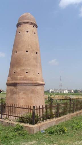
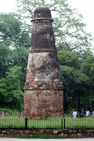

Babur, in 1528, ordered one of his Central Asian nobles, a certain Chiqmaq Beg, that he, with the assistance of the royal clerk, should measure the road between his new capital Agra and Kabul. The emperor ordered that at every ninth kos, the noble should erect a 12 qaris (24ft or 36ft) high tower, topped with a superstructure having four openings. These were the kos minārs. As actually measured between some sets of these minars near Delhi, 1 kos measures about 4.17 kilometres.
This tradition was later followed by Sher Shah Sur who orders such milestones to be built along the network of roads he laid out. Along these kos minārs were his sarais and dāk chaukīs. This tradition was further carried forward during the next reign. Akbar is recorded to have built kos minars along the road from Agra to Ajmer.
Later on in 1619, Jahangir ordered Baqir Khan, the faujdar of Multan, to erect kos minars from Agra to Lahore. A large number of these milestones are extant to date, Thirty-four of these, in varying states of preservation, still survive in Punjab.
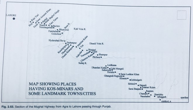
Although these surviving kos minars broadly follow the same design, still some of these have graceful proportions whereas others are somewhat clumsy.
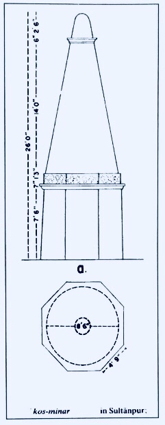
A number of them have wedge shaped stones studded on them: a few now just carry the hole where these stones were fixed. These kos minars never carry any tnscnption on their body.

The Hiran Mīnār of Fathpur Sikri is an ākāshdiya as well as the Zero-Mile Stone of Fathpur Sikri.
It stands (as an akashdiya) just in front of the main entrance of the fort. A miniature from the manuscript of the Akbarnama preserved at Victoria and Albert Museum [“Akbar’s victorious return to Fatehpur Sikri”, outline by Kesav the Elder, painting Nar Singh, opaque watercolour and gold on paper, Mughal, ca. 1590-95, IS.2:110-1896] testifies that this indeed was the entrance gate the palace beyond which the Hiran Minar can be seen!

A one kos road leads to it if one enters through the Bharatpur Gate of the city. And then from the Minar to just outside the Ajmeri Gate is another kos where stands another kos mīnār. It’s horn-shaped stone have long since disappeared and only the holes where they were once fixed remain.

Jahangir had given general orders to fix these deer-like horns on his Kos Minars erected on his road from Delhi to Lahore: he was possibly only duplicating what he had seen as a child in his father’s zero-mile stone which stood at the gate of the palace and near the grand polo grounds on the banks of the lake!
If one tries to draw a circle with Hiran Minār as the centre, the whole town with its lake fits into this circle. It was not only the central focal point around which the town was planned but also an architectural feature which marked the “face” of the capital city of Akbar!

