Me & Maulana Azad Library

It was in 1877 when Lord Lytton laid the foundation of Mahommadan Anglo-Oriental (MAO) College at Aligarh. Along with it was established the Lytton Library, named after Lord Lytton, the Viceroy of India (1876-80).

This library which catered to the needs of the students of the College was initiated with the books from the personal collection of Sir Syed. Subsequently many friends and followers of Sir Syed started contributing their own personal collections to it. It was thus that, amongst others, it aquired the Sherwani Collection contributed by Nawwab Rahmatullah Khan Sherwani. The Lytton Library was originally housed near the Asman Manzil, within the precincts of the MAO College campus, now known as SS Hall. After Independence, it was not only renamed after Maulana Abul Kalam Azad, the first Education Minister of Independent India, but it was shifted outside the precincts of the College. It came to be housed near the Shamshad Market, in the building now known as Sultan Jahan Manzil.

It was there that the then first king of the Saud family to visit India, Ibn Saud; the Shah of Iran, Muhammad Reza Shah Pahlavi Arya Mehr along with his second wife Soraiyya; and King Daud of Afghanistan visited it.

In 1955, Pandit Nehru, the first Prime Minister of India laid the foundation of its independent building where it is lodged in till date. Nehru inaugurated the new Maulana Azad Library in 1960.

I have a personal connection with this library. The then Vice-Chancellor of Aligarh Muslim University, Dr. Zakir Husain, in 1954 invited my father Saiyyid Sibtul Hasan, to come and join as the Incharge Manuscripts Section of the Library. My father had been the Librarian of the State of Mahmudabad which was known for its Arabic and Persian collection. Having joined the Library in 1954, my father retired from it in 1972.

Though he was responsible for giving shape to the Manuscript Section, as the most celebrated section of the Library, my father was never given a promotion and made to retire from the same position on which he had initially been appointed! Till his death, the poor man was not even released the pension which was due to him. Reason being that the dealing clerks of the Registrar’s office reported an overwriting on his pension form, and the respective Vice Chancellors till his death in 1978, did not find time to go through his file. His widow, my mother, could finally get his pension only almost 25 years after his death. To discriminate against its own, has probably been a well-established tradition and trait of AMU. Spread over 8 floors and a basement, the library today boasts of atleast 5 massive reading halls, besides seminar rooms, stacks, staff rooms and offices. The process of digitisation of catalogue has been completed and now the process of digitisation of books has been initiated. As in the initial days, the library still caters to the academic needs of the university students- both boys and girls, who can not only sit and study there, but also get books and textbooks issued in their names. So is the case with the entire academic staff of the University who are or can become its members. The only exception till very recently were the students of Abdullah Girls College, who had to depend on the resources of their College. They were told that they have a Library in their college. But after sustained efforts they too are now theoretically allowed. Recently a few separate Girls Reading Rooms have also been added. Yet much more is needed to be done. Unfortunately since some time no visionary University Librarian has been appointed: those who are there are more technocrats and event managers, instead of those who understand books! Even the basic sense of how to display and keep manuscripts is lacking. The Manuscript section, which is the heart of Maulana Azad Library boasts of an unprofessional and incomplete catalogue!

Today the seven-storey building is surrounded by 4.75 acres (1.92 ha) of lawns and gardens. It has about 1,400,000 books.

The library has a sizeable collection of early printed books in many languages including Latin translation of the Arabic work Book of Optics by Ibn al-Haytham (965-1039) published in 1572. The Library holds an invaluable collection of 15,162 rare manuscripts, one of which written on parchment in Koofi script is claimed to be inscribed by Hazrat Ali (the fourth Caliph of Islam) 1400 years ago.[9] Other items in the collection include several farmans (decrees) issued by Mughal rulers (including Babur, Akbar, Shahjahan, Shah Alam, Shah Alamgir, and Aurangzeb);[1] a “shirt” on which the whole Qur’an is inscribed in khafi script; the Ayurved written in Telugu; and works by Bhasa written in Malayalam on palm leaves.

The Oriental Division of Maulana Azad Library consists of about 200,000 printed books and periodicals. Donations received have been designated as special collections by the names of their donors. The Urdu collection with more than 100,000 books forms the largest part of the Oriental Division. A substantial number of rare and out-of-print publications of the 19th century belong to the Scientific Society of Sir Syed Ahmad Khan, Fort William College (Kolkata), Delhi College, Agra College and from the Royal Printing Presses of the courts of Delhi and Oudh.

Among the large collection of Mughal paintings is the famous painting of Tulip by Mansoor Naqqash, court artist of the Emperor Jahangir. Some valuable Sanskrit works translated into Persian have also been preserved in the library. Abul al-Faiz (Faizi), an eminent scholar of Akbar‘s court translated several Sanskrit works into Persian, such as Mahapurana, Bhagavad Gita, Mahabharat and Lilavati.

Prof. Zahiruddin Malik (July 1925 – May 2008)

He was born at Nahthaur in the district of Bijnore in a distinguished family. He was an alumnus of the Aligarh Muslim University from where he obtained his B. A., M. A. and Doctorate. He completed his M.A. in 1951 and then his Ph.D. and join AMU as a lecturer. Prof. Zahiruddin Malik served the department of History for more than forty years with distinction.

His Book A Mughal statesman of the eighteenth century, Khan-i-Dauran, Mir Bakshi of Muhammad Shah, 1719-1739 is generally recognized as standard work on the subject.

Another work from his pen is Agrarian System In Medieval India which is based on the newly discovered contemporary source material. It examines the law revenue structure in sarkar Shahabad in Bihar under the Mughals and the changes effected therein by the British during 1734-1790. In this work he used contemporary historical evidence to support his arguments.

His most remarkable work however is The reign of Muhammad Shah, 1719-1784. This is the magnum opus of the author wherein he changed the hitherto perceived notions that the first half of the eighteenth century was a period of cultural decadence and political decline. In his biography of Muhammad Shah he showed that the period in Indian history witnessed socio-economic prosperity and cultural efflorescence.

In 2001 he published another significant work Agrarian System in medieval India a micro study of Land Revenue arrangement in Sarkar Shahabad (Bihar), 1734- 1790 published from the Center of Advanced Study department of history.

His other works include a biography of an important Turani noble entitled ‘A Mughal statesman of Eighteenth century “Khan–i-Dauran“, Mir Bakhshi of Muhammad Shah 1719-1739, illuminates life of Mughal nobility in what is considered an age of decline in graphic details.

One of his last academic engagements in the Department before his demise was in an international Seminar organised by the History department on Syed Ahmad the founder of the University and contributed a paper on the political ideas of Sayyid Ahmad Khan.

One of his earlier essays another ‘Some Muslim Patron saints of Hindu chiefs in North India and the impact of their interactions’, is another example of his broad vision and liberal approach to his subject. Another of his article “Some Muslim Patron saints of Hindu chiefs”, also points to his broad vision and deep insight approach in research.

Apart from his academic activities, Malik Sahib remained also remained active in other engagements of the Department. For many years he was the Teacher Incharge of the Department Library. I remember when I was a PG student in 1980-82 sessions, he would pay us surprise late night visits. A number of times he would suddenly walk into the MA Students Seminar Room at 3:00 am to check whether we were studying or not!

He remained actively engaged in research even after retirement in 1984 and took a lively interest in the academic concerns of the members of the department and over all issues related to the University community his alma mater.

A Personal Note:

To me he was more than a teacher! I remember when after the Baburi Masjid demolition there were all round riots and unending curfew, he would be very concerned if we were getting the necessary supplies or not! Many a time he would walk over to our house with eggs, butter, bread and packets of cigarettes which he had bought and arranged for me during the curfew! And then many years later when I was shifting house, he and his daughter not only offered but brought lunches and dinners for us consecutively for three days! Malik Sahib would bring us the food prepared by his daughter! And when I had some trouble with the then Chairman, a certain Shahabuddin Iraqi, he with full concern met him a number of times to solve the problem. He was through out a loving mushfiq teacher who was always concerned about his students. Though I had never directly studied any course from him, he considered me his student!

Professor Khaliq Ahmad Nizami (1925-1997)

Born on 5th December 1925 in Amroha (UP) and brought up and educated in Meerut, Professor K A Nizami was one of the very well known historians of Medieval India. He wrote extensively on Sufism and the political history of the Delhi Sultanate. He was a prolific writer and has many books, edited works and research papers to his credit. However his most popular contribution is The Comprehensive History of India, volume 5 which he co-edited with Professor Mohammad Habib, his mentor who had brought him from Meerut to Aligarh in 1947.

In 1953 he became reader in history, and in 1963 he was promoted to the rank of professor. He was the last Head of the Department (1968-84). Before his retirement he also served as Indian Ambassador to Syria. For some time (3 January 1974 to 30 August 1974) he was also the Acting Vice-Chancellor of AMU.

One of the more consequential of his efforts was the publication of the political correspondence of the 18th-century Muslim reformer and philosopher Shah Waliullah of Delhi; this correspondence provided the basis for an enlarged understanding of Shāh Waliullah’s contribution to Indian history. Nizami also had a large number of works devoted to Sir Saiyid Ahmad Khan, the founder of the Aligarh Muslim University and the most important intellectual and political leader of the Indian Muslims in the latter part of the 19th century. In addition to the studies of the life and times of Sir Saiyid and the history of the Aligarh movement, these studies include an illustrated album and a collection of poems about the great Reformer and some of his associates.

As a post graduate student I had the honour of offering two courses which he used to teach, viz., the Political History of Delhi Sultanate, and a course on Muslim Religious Thought. His teaching of the later course was something remarkable: being almost a mystic, he would go into a trance discussing the finer points of Sufic thought, like wahdat ul wujud. There would be pin drop silence in the class as his voice would sometimes soar or choke! He would for minutes be looking out of the window with his sight fixed nowhere and then he would suddenly snap out of the trance and say, “forget it! You won’t understand!”

His handling of the first course however left us wanting for more: for what he would tell, was already written in his famous “Volume 5”!

His aura was such that whether you wanted to or not, you would be awe-struck! We used to call him ‘Balban’! He would arrive in a jeep. The driver, Mr Shareef would blow the horn while the jeep was still near the VC lodge, and hearing that everyone in the department would be alerted that Sultan Balban was arriving!

Once I went to his home to report that some senior students had tried to manhandle me as I had come to the Department wearing a kurta over a jeans. Nizami Sahib tried to cool me down by giving me a steaming hot cup of coffee. As I sipped it sitting in his library, he turned to me and said: ‘When as a student one day I came wearing a T-shirt all hell broke loose. Now you see me coming daily in half sleeves! Times change! A day would come when kurta would be acceptable! But remember to succeed: Do in Rome as Romans do!’ By the time my coffee finished I was thanking him and my anger had disappeared.

A man of noble demeanour and character, Nizami Sahib was a great influence on the campus. Later in life, when I came to occupy the Office where he used to once sit as Chairman and Coordinator, CAS Department of History, the Chamber would always remind me of him. Quite frequently I would imagine while entering the room which now was mine, that with a swivel of the upholstered chair, he would get up and glare at me through his penetrating eyes. Throughout the three years that I remained an occupant of that room, memories of Professor Nizami would engulf me on a daily basis!

I remember one day walking in late to a Friday Seminar which used to be chaired by him for the research scholars. His own research student, Mr Iqbal Sabir, was making a presentation. As I stealthily entered the room, being late, I had a sweater casually thrown on my shoulders. He leaned forward and almost pierced me through his glare. When the lecture was over and I, to make matters up, raised my hand to ask a question, Nizami Sahib with a gesture of his hand brushed aside Iqbal Sabir and shot a counter question towards me: “Miyāñ āp kisi ground me khelne āye haiñ? Ya seminar me? Tak off your sweater from your shoulder! Either wear it or hold it properly”! He was a strict disciplinarian with a no nonsense approach. A man of the old world, he did not tolerate any act of indiscipline or demeanour!

As a favourite student of Professor Mohammad Habib, he was a well known scholar of mysticism and most of his work was dedicated to the development of Sufism under the Delhi Sultans. However, a few of his works also extended until the Mughal period.

The void created by his absence has yet to be filled. Whether one politically agreed with him or not, one can never dispute his high place in the firmament of the sacred pantheon of the Department! He was a giant amongst the giants. He will always be remembered as an Alig and as a historian of the Aligarh School!

The Iron Pillar at Mehrauli

Fronting the maqsura (screen) of the Qubbatul Islam Mosque and located within the courtyard is an iron pillar. What was this Iron Pillar, where was it originally and what its inscriptions read, I give below. As for its re-use, and why was it resorted to, please read Finbarr B Flood, “Pillars, Palimpsests & Princely Practices: Translating the Past in Sultanate Delhi”, RES: Anthropology & Arsthetics, no 43, 2003, pp. 95-116

The Iron pillar carries a number of inscriptions and graffiti of different dates which have not been studied systematically despite the pillar’s prominent location and easy access. The oldest inscription on the pillar is in Sanskrit, written in Gupta-period Brahmi script. This states that the pillar was erected as a standard in honour of Viṣṇu. It also praises the valor and qualities of a king referred to simply as Candra, now generally identified with the Gupta King Candragupta II. Some authors attempted to identify Candra with Chandragupta Maurya and yet others have claimed the pillar dates as early as 912 BCE. These views are no longer accepted.

The dating of the inscription is supported by the nature of the script and the Sanskrit poetics, both of which reflect the conventions of Gupta times. Thanks to the tablets installed on the building in 1903 by Pandit Banke Rai, the reading provided by him enjoys wide currency. His interpretation has, however, been overtaken by more recent scholarship. The 1903 tablets read as follows:

He, on whose arm fame was inscribed by the sword, when, in battle in the Vanga countries (Bengal), he kneaded (and turned) back with (his) breast the enemies who, uniting together, came against (him);-he, by whom, having crossed in warfare the seven mouths of the (river) Sindhu, the Vahlikas were conquered;-he, by the breezes of whose prowess the southern ocean is even still perfumed;-

(Line 3.)-He, the remnant of the great zeal of whose energy, which utterly destroyed (his) enemies, like (the remnant of the great glowing heat) of a burned-out fire in a great forest, even now leaves not the earth; though he, the king, as if wearied, has quit this earth, and has gone to the other world, moving in (bodily) from to the land (of paradise) won by (the merit of his) actions, (but) remaining on (this) earth by (the memory of his) fame;-

(L. 5.)-By him, the king,-who attained sole supreme sovereignty in the world, acquired by his own arm and (enjoyed) for a very long time; (and) who, having the name of Chandra, carried a beauty of countenance like (the beauty of) the full-moon,-having in faith fixed his mind upon (the god) Vishnu, this lofty standard of the divine Vishnu was set up on the hill (called) Vishnupada.

The inscription has been revisited by Michael Willis in his book Archaeology of Hindu Ritual, his special concern being the nature of the king’s spiritual identity after death. His reading and translation is as follows:

[khi]nnasyeva visṛjya gāṃ narapater ggām āśritasyetarāṃ mūrtyā karrmajitāvaniṃ gatavataḥ kīrtyā sthitasya kṣitau

śāntasyeva mahāvane hutabhujo yasya pratāpo mahān nādyāpy utsṛjati praṇāśitaripor yyatnasya śeṣaḥ kṣitim

The residue of the king’s effort – a burning splendour which utterly destroyed his enemies – leaves not the earth even now, just like (the residual heat of) a burned-out conflagration in a great forest. He, as if wearied, has abandoned this world, and resorted in actual form to the other world – a place won by the merit of his deeds – (and although) he has departed, he remains on earth through (the memory of his) fame (kīrti).

He concludes: “Candragupta may have passed away but the legacy of his achievement is so great that he seems to remain on earth by virtue of his fame. Emphasis is placed on Candragupta’s conquest of enemies and the merit of his deeds, ideas which are also found in coin legends: kṣitim avajitya sucaritair divaṃ jayati vikramādityaḥ, i.e. ‘Having conquered the earth with good conduct, Vikramāditya conquered heaven’. The king’s conquest of heaven combined with the description of him resorting to the other world in bodily form (gām āśritasyetarāṃ mūrtyā), confirms our understanding of the worthy dead as autonomous theomorphic entities.”

One of the later inscriptions dates to A.D. 1052 mentions Tomara king Anangpal II.

Alexander Cunningham (1862–63) read the inscription as follows:

Samvat Dihali / Dhilli / Killi 1109 Ang Pāl bahi

[Samvat 1109 [1052 AD], Ang [Anang] Pāl peopled Dhilli

Based on this reading, Cunningham theorized that Anangpal had moved the pillar to its current location while establishing the city of Delhi. However, his reading has been contested by the later scholars. B R Mani (1997) who contrarily read it as follows:

Samvat Kinllī 1109 Angapala bādi

[Anangpal tightened the nail [iron pillar] in Samvat 1109]

The term Dhillika, interestingly, first appears in the Bijhli rock inscription found in district Udaipur, Rajasthan which was issued by the Chahamana (Chauhan) ruler Someshwar in VS 1226 / 1169-70 while describing the city now known as Delhi.(Epigraphica Indica, XXVI, 1941-42, no. 9, pp. 84-112).

Some scholars, without any substantial basis, have suggested that the iron pillar was installed in its current location by Vigraha Rāja, the ruling Tomar king.

While the pillar was certainly used as a trophy in the building the Quwwat-ul-Islam mosque and the Qutb complex, its original location, whether on the site itself or from elsewhere, has frequented discussion. A summary of views on this subject and related matters was collected in volume edited by M. C. Joshi and published in 1989. More recently, opinions have been summarised again by Upinder Singh in her book Delhi: Ancient History.

R. Balasubramaniam explored the metallurgy of the pillar and the iconography based on analysis of archer-type Gupta gold coins. In his view, the pillar, with a wheel or discus at the top, was originally located at the Udayagiri caves, situated near Vidisha in Madhya Pradesh. This conclusion was partly based on the fact that the inscription mentions Viṣṇupadagiri (meaning “hill with footprint of Viṣṇu”). This conclusion was endorsed and elaborated by Michael Willis in his Archaeology of Hindu Ritual, published in 2009. The key point in favour of placing the iron pillar at Udayagiri is that this site was closely associated with Chandragupta and the worship of Viṣṇu in the Gupta period. In addition, there are well-established traditions of mining and working iron in central India, documented particularly by the iron pillar at Dhar and local place names like Lohapura and Lohangī Pīr. The king of Delhi, Iltutmish, is known to have attacked and sacked Vidisha in the thirteenth century and this would have given him an opportunity to remove the pillar as a trophy to Delhi, just as the Tughluq rulers brought Asokan pillars to Delhi in the 1300s.

Atithi Deva Bhavo!

This photo reminded of an incident which happened to me in 2003. High Court ordered excavations were going on at the site of the Babri Masjid and Ayodhya which had been demolished by the goons going by the name of kar sevaks.

The erstwhile mosque had been totally raised to the ground and just below where there had been the central dome of the mosque, a make shift mandir of Ram Lalla had been erected.

The tempers were high and the whole nation was waiting with baited breath to know what would be discovered by the ASI diggings.

At the site the High Court had stationed two magistrates, one a Hindu, another a Muslim. The cordoned off site was heavily guarded by a heavy posse of CRPF, RAF and PAC jawans. And as generally ASI team was perceived as an “agent” of VHP / BJP and thus daily disputes over diggings were a common feature, the Court had also appointed a number of independent Observers. They were to be present on the site and keep a hawks’ eye on how the digging was being done, what were the finds and how were they being reported.

Each Observer would be sent for a few days and then replaced by another. He / she would note what being done and sometimes object to the shoddy manner of what ASI was doing. I also had the privilege of being one such Court appointed Observer and was there on the site a number of times. The Observers were usually at loggerheads with the ASI officials on the site. When in the evening each days findings were noted and photographed, the magistrates, lawyers of all sides and parties, the representatives of the Babri Masjid Action Committee, the Nirmohi Akhara, the litigants as well as the Observers would all assemble and take note of what was being reported. Observers would also dispute with ASI in case of any anomaly! Thus they were taken to be “suspects”, the “other”!

Even otherwise, some of the Observers were suspect because they were Muslims! Although most Observers were generally Hindus…RC Thakran, Supriya Varma, Banani Bhattacharya, Jaya Menon etc. They were equally suspect. Continue reading Atithi Deva Bhavo!

Gaur: The Capital of Sultanate Bengal

A team of state archaeologist from Bengal led by scholars like Professor Aniruddha Ray, Prof Ratnabali Chaterjee and others (e.g. Sutapa Sinha) worked on Gaur,the medieval capital of Bengal. This blog is based on the various research papers written by Prof. Ray and Dr Sinha.

After extensive explorations and some ‘debris cleaning’, they contributed a number of research papers. Recently (february 2013) a whole issue was also devoted to this city. Here I give a sum total of these works for a layman’s understanding:

CITY OF GAUR

The history of the Sultanate period in Bengal is marked by the absence of contemporary source material unlike other Sultanates in India. The hot and humid climate of Bengal may be one of the reasons for this complete absence written records. The political history of the period is thus primarily dependent on the epigraphic and numismatic evidences.

Gaur or Lakhnauti, as it was named after Lakshmanavati, was the capital of the Sultanate Bengal from 1213 to 1324 A.D. Between 1333-1339 the seat of power shifted to Firuzabad, popularly known as Hazrat Pandua. “The causes of this transfer are nowhere stated ; but it was obviously connected with the changes in the river courses, making Lakhnauti unhealthy and uninhabitable. The various civil wars, with repeated plunderings of the city, might have hastened the transfer.”(M. M. Chakravarti “Notes on Gaur”, JPASB, Vol. V, 1999, No.7, pp.204-234)

The capital was again shifted to Gaur during the reign of Sultan Nasir al-din Mahmud Shah, between 1437-38 and 1450-51 AD. This transfer was again largely due to physical changes in the locality. Quoting MM Chakravarti, “After much fluctuation, the Ganges seems to have found a comparatively stable course on the west of the city and its floods probably raised the level of the city on its eastern part.”

The city of Gaur began to flourish during the reign of the subsequent rulers of the later Ilyas Shahi dynasty. On the accession of Sultan Husain Shah in 1493AD Ekdala emerged as the seat of Sultanate in place of Gaur and it remain capital till at least 1505 after which the capital once again reshifted to Gaur during the later half of the reign period of Sultan Husain Shah. Ultimately in 1565 Sulaiman Kararani removed the capital from there to Tanda which is further south-west. In 1575 Munim Khan, the first viceroy of Akbar, re-transferred the seat of Government from Tanda to Gaur but due to an epidemic which broke out in the monsoon of that year, Munim Khan was forced to return to Tanda where he died after ten days on 23rd October 1575.

In 1595 Raja Man Singh removed the seat of Government from Tanda to Rajmahal (then known as Akhmal) on the other side of the Ganges. Fluctuations in the river course were probably the main cause of the transfer.

Shah Shuja who Governed Bengal during 1639-1660, although he added some buildings to Gaur, usually resided at Rajmahal and Gaur never afterwards was the seat of the Government.

The city of Lakshmanavati where Ikhtiyar al-din Bakhtiyar Khalji and his successors established their capital, has not been identified with certainty. The present day ruins at Gaur belong to the second city of Gaur, which flourished from the middle of 15th century on the bank of the river Ganges. But the decline of the city started in 1583 AD when Sher Shah invaded Bengal and burnt and sacked the city. During his viceroyalty, Shah Shuja sent some of his personnel to Gaur in search of treasure trove in the deserted palace of the Bengal Sultans. Frey Sebastian Manrique has given a vivid description of his arrival to the palace of Gaur, attracted by the massive wall of the Palace while passing through the river sometime in 1641. The vast number of buildings which survived the destruction and desertion were further damaged by the freaks of nature and human vandalism. The climate of Bengal was equally inimical to the preservation of building remains. More destructive force was the purposeful demolition of the buildings to carry boatloads of curved stones and glazed bricks to Rajmahal, Murshidabad, Hughly and Calcutta.

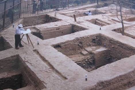
Therefore, very few buildings are now extant in one of the most populous and great city of medieval India, mostly the religious building are spared and a few bridges, gates and ruins of other structures remained to remind us of lost glory of the city. The mud city wall or embankment however, is in a tolerable shape of existence, which help us to delimit the area of this vast city. The landscape of the city is punctured with innumerable tanks and ponds amidst waste land littered with brick bats. The city of Gaur, remains largely buried and unless systematic excavation is carried out in the different areas it is very difficult to form a clear idea of its integral parts. Thus a research project was undertaken by the Directorate of Archaeology and Department of Islamic History and Culture, University of Calcutta, in 1992 entitled “Pattern of Urbanizaion in Medieval Bengal – A case study of Gaur Pandua Complex”.

The fortified city of Gaur covers an approximate area of 46.473 Sq. Km and falls within the Modern English Bazar Police Station of the district of Malda, West Bengal. The southern suburb and a small portion of the main city of Gaur is however within the administrative jurisdiction of Chapai Nawabganj district of Bangladesh. The city lies between 24 50′ 44″ and 24 55′ 50″ N latitude and 887′ and 8810′ E longitude. It was bounded by an embankment on the north, double embankments on the east, the Ganges on the west and a single embankment on the south. On the west of the city along the river, there was also a mud embankment traces of which are still visible in some places. The double embankment on the east was constructed to ward off the water of a huge marshy lake known as Chatia Patia.

The fortification wall was relieved with two principal gateways, one in the north called Phulwari Darwaza and the other in the south called Kotwali Darwaza which served as the main entrance to the city.

These two gateways were connected through one arterial road, which was known in the 19th century as Shibganj Road. This road vertically dissected the entire city. Another road was also running parallel to the main arterial road upto Chamkatti mosque and then took a bend towards west at a sharp right angle and ends near the Choto Sagar Dighi. Two more gateways can be traced on the northern city wall which provides easement to the city.

The general topographical slope of the area is from north to south. A number of tanks, ponds, swamp and canals suitably spaced relieve the landscape. The entire tract of land is raised from surroundings and is not easily prone to inundation during the rainy season, except the north-eastern low lying tract.

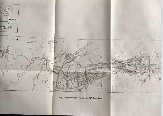
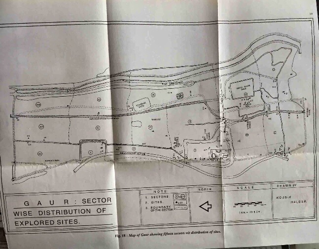
To facilitate exploration work in the city of Gaur, the accurate survey map prepared in 1878 by J.H. Ravenshaw was used and to systematise the work, the entire area of the city into 15 hypothetical sectors.

The city of Gaur can broadly be divided into four principal functional zones; the Royal Center, the Noble’s Quarter, the Urban Core and the Garrison Area. Another distinct zone can also be defined from the reassembled map, which we have termed as “Fringe area”. People of secondary occupation may have lived here. The extreme northern and north -eastern tract is a low land like a shallow basin and was probably used for cultivation of emergency crop when the city was besieged.

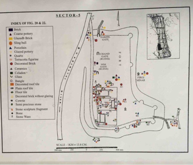
The Royal Centre, i.e. sector 5 in the base map – is the citadel containing the Palace complex and some other monuments in its surrounding. It is easily identifiable through the massive citadel wall, mostly extant, strengthened with bastions at the corners and surrounded by a deep moat outside and pierced by three prominent gateways. The imposing citadel occupies the most pronounce and advantageous position in the city and is situated on the highest ground on the eastern bank of the Bhagirathi, now a dried up streamlet. Some 46 sites have been identified within the citadel area.

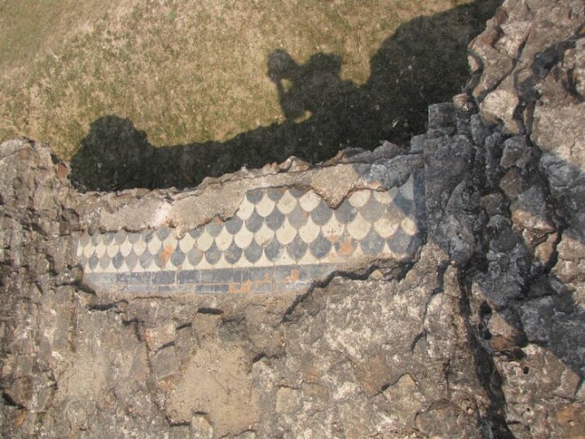
The Palace itself was rectangular and was enclosed on three sides by a high brick wall measuring 42 feet high which is still extant in most part on the northern and eastern sides. The enclosed area of the Palace measures approximately 300 Mts. x 100 Mts. and is divided into three unequal rectangular compartments. Legend says that the first compartment from the north was the Durbar hall and treasury of the Sultan. The second was the living apartment of the Sultan while the third one was traditionally known as the Haram. Each compartment having a tank within it was separated by a dividing wall – remnants of which can only be traced from the deep burrow created by the brick robbers worked since ages.

From the nine sites of the First compartment plenty of architectural fragments of stone as well as decorated bricks (18.06%), glazed bricks (16.12%), floor tiles (9.68%) and glazed pipes (12.90%) have been found along with extant areas of a white tiled floor.

The percentage of potsherds, either of coarse pottery (18.70%) or of Porcelain (12.90%), is very little compared to the other living apartments of the Palace. There were several huge structural mound in the compartment , full of decorated bricks strewn all around, mostly of similar geometric designs of blue and yellow on white due to which it can be identified as the ruins of the Darbur hall.

The Archaeological Survey of India has excavated this particularly area since 2001 and a massive structural complex came out which very interesting and perhaps unique in Eastern India, if not in India.

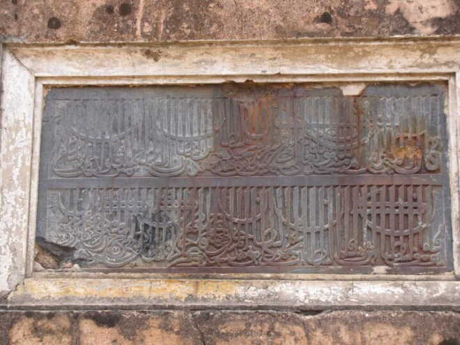
In an inscription of Sultan Barbak Shah, there is a mention of construction of an underground water course of cold water flowing beneath the palace which could be compared to the fountain of heaven. But we are not sure what it exactly was and what was the functional aspect of such construction.

The Second compartment offered very rich archaeological material. The nature of artefacts found from this area gives credence to the tradition that this compartment was used by the Sultans as their personal residence or Khas Mahal. At the North West corner, a portion of a beautiful bi-chrome tiled floor, of blue and white tile, still exists.

Surface survey of this area yielded highest number of artefacts comprising of finest quality of porcelain shards (47.26%), celadon ware (6.08%), shards of buff coloured ceramics (1.42%), coarse pottery (19.68%), decorated bricks (5.88%), glazed tiles (5.88%), glazed pipes (2.23%), cawrie shell (0.81%), glass bangles & glass bowls (2.63%) etc. Among the porcelain shards, the most interesting and remarkable finds are thin and fine white porcelain shards with blue coloured pre-fired inscriptions on them. The script of the inscription is proto-Bengali and the style of calligraphy belongs to 15th- 16th century. A few porcelain with Chinese inscription, especially potter’s mark at the bottom of the pot and sherds of pre-Ming porcelain with self-design have also been found. Most of the porcelain sherds are decorated with typical Chinese blue on white designs but not always of a very fine quality. Different quality of porcelain with various thickness and fabrics collected within this compartment indicates a regular inflow of imported Chinese porcelain as luxury item of the royalty.

The third compartment of the palace is traditionally known as the Zenana Mahal or Harem, the living apartment of the women. A stone paved tank on its eastern side marks this quarter. Exploration in the third compartment was greatly hampered by cultivation of seasonal crops and mulberry culture and a thick cluster of mango groves. Beyond the third compartment, an area was located that can be termed as service area of the Palace.

On the north of the citadel was the main entrance – called Dakhil or Salami Darwaza. One could make a straight approach from this gate to the palace proper through a raised paved road. Ruins of two intermediary gateways on this royal road have also been located, traditionally known as Chand darwaza and Nim Darwaza, which no longer exists but was standing in the late 18th century as Crieghton made a beautiful painting of one of them.

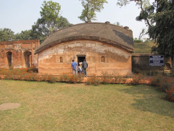
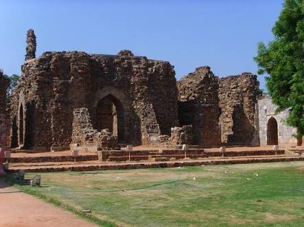
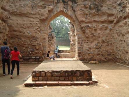
To the east of the Palace, two distinct zones have been identified as the burial ground of the Sultans and their families: Cemetery A & B. The former is located on the north east of Palace where according to 18th century records lay the tomb or Mausoleum of Sultan Husain Shah and his dynasty, which is now in complete ruins. No mausoleum exist in this Cemetery complex but a large mound filled up with scattered pillars, number of tombstones, beautifully ornamented polychrome bricks indicate the ruins of a Royal cemetery. The team has even located the remains of the enclosure wall of the cemetery, now in ruins but was extant during the days of Henry Creighton, a Scottish Indigo planter of 18th century who has left us a brilliant drawing of the site. The glazed bricks collected from this burial site are brilliant and exclusive in design and colours. ASI has also excavated this area and opened up the foundation of the building.

An excavation conducted by the ASI near Chika monument in 1940’s laid bare a series of burials. The Chika building could well be a mausoleum without the tombstone above the ground, which is lost and may have entombed the mortal remains of a principal Sultan or Sultans of the later Ilyas Shahi house. A mosque is located on the west of Chika monument which was earlier thought as a remains of a cemetery building of which only the bases of load bearing pillars, thirteen in number and another two rows of stone pillars are standing forming a rectangular plan.

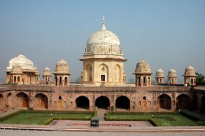
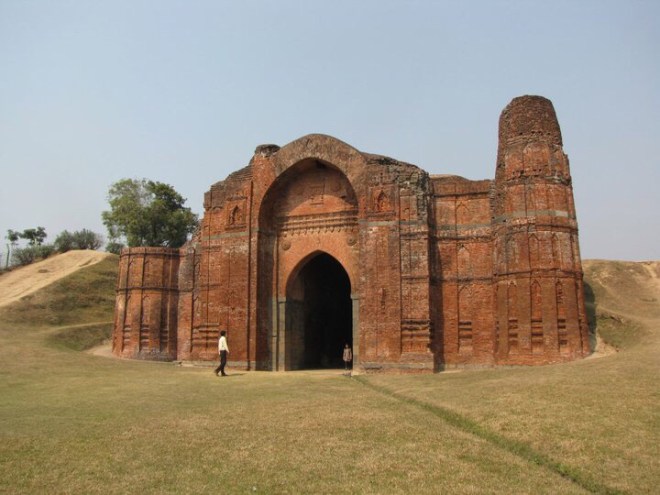
To the east of this Chika monument, is a gateway standing on the citadel wall named Gumti gate, standing on the same axis. This small gateway may have been constructed for the use of private easement of the members of the royal family. This domed structure with its magnificent brick ornamentation on the walls and also on the turrets at the four corners is dissimilar in architectural style to the other gateways of the citadel or of the city. On further left of it is situated the eastern main entrance of the Citadel named Lukochuri Darwaza which is evidently a building of the Mughal period, most probably built by Shah Shuja during his short stay in Gaur. But there is a strong possibility that this later structure was built on the site of a previous gateway, which originally used to connect the Citadel with the southern part of the city through a raised road. We will see later that the court nobility most probably inhabited in the south-east of the citadel and therefore an eastern gateway of the Citadel was absolutely necessary for frequent easement. Within the Citadel, the only religious structure is Qadam Rasul that enshrines the sacred footprint of Hadrat Muhammad. Aside Qadam Rasul with its porched liwan, which can be used as a place of worship, surprisingly, trace of no other mosque has been found within the Palace-Citadel complex.

The next zone to be discussed is the Noble’s Quarter of the city which falls within the sector 3 (fig. 22) of the working map where we have located eleven sites altogether. The area is situated in the south east of the Citadel and not very far from it, connected with the main arterial road of the city that directly leads to the Kotwali Gate, the southern entrance of the city. It is an area of about four square Kms around the largest tank of the city locally known as choto sagar dighi, the main source of water supply for the locality. There is another landmark, almost hundred meters north of this tank is the ruin of Belbari Madrasah, the principal place of learning within the city. In the southern suburb of Gaur, which is presently in Bangladesh, another madrasah has been located and partly excavated by the Archaeological Department of Bangladesh, known as Darasbari madrasah. The Belbari Madrasah is at present in utter ruins The entire structure of the Madrasah building has fallen down and formed a huge mound locally known as Chand Saudagarer bhita over which are scattered a number of pillars with typical Islamic curving.

The intellectual class and the supportive apparatus of the administration probably inhabited the area. Exploration conducted in this sector revealed ruins of extensive habitation in the area between sagar dighi and the arterial road of the city and also around the Madrasah. A bridge of three arches was found behind the Madrasah where a raised road has crossed a canal flowing in east-west direction. This road was running parallel with the main arterial road from the north of the city as a bypass and was connecting the Madrasah with another most important part of the city namely urban core, which will be discussed next. The road ends at the south eastern corner of the choto Sagar dighi. A number of structural mounds relieve the topography of the zone, which indicates the remains of residential building. The quality of the archaeological artefacts found together with the close cluster of ruins of residential structures in proximity of the royal centre help us to identify the sector as the Noble’s Quarter. Nevertheless, the quarter was also carefully planned for habitation of the elite class and provided with largest source of drinking water in vicinity and other urban amenities such as easy access to the main arterial road of the city, well planned canal made both for carrying of daily waste as well as diffusion of excessive rain water from the large lake on the east, connecting subsidiary roads with other part of the city.

The third important and the largest zone in the city has been termed as Urban Core comprising of Sectors 1,2, 4 and 6. On the basis of the surface explorations, the area around the Royal Palace stretching from Great Golden Mosque [Bada Sona] on the north to the city wall on the south and double embankment on the east to the bank of the Bhagirathy on the west can roughly be defined as the Urban Core of the medieval city of Gaur. This part of the city is situated around the royal centre in a half circular manner and was warded off from the fringe area by a raised causeway. Density of population here was probably the highest as revealed through the traces of clustered settlements, occurrences of large and small tanks, bridges, mosques, canals, high ways and causeways and other structures and monuments.

At the northern end of urban core lies the principal mosque of the city known as Bada Sona Mosque used for the weekly congregational prayer (sector 6). The area to the west of it is marked by a structural mound with stone pillars scattered around, traces of sewerage system and a large concentration of the usual archaeological assemblages of medium to inferior quality denoting the area to be extensively populated and frequented by all classes of people and probably having a market place within it.

Just opposite the Noble’s Quarter, (sector 4) on the right hand side of the arterial road stands the grand Tantipara Mosque. The size of the mosque and its rich terracotta decoration on the façade and in inside, suggests that it used to cater a large number of people belonging to the elite core. Surprisingly enough, the result of surface exploration in and around the mosque belies the suggestions because the artefacts are of quite inferior quality and distribution of them is very sparse and erratic as well. However, we should mention here that a considerable part of this sector is completely unapproachable due to thickets and cultivation of mulberry.

The sector east of the main arterial road i.e. sector 2 has not been explored thoroughly since a considerable portion of it falls within the modern Bangladesh. The zone is marked by raised causeway starting from a Bridge named Nungola on the main canal on the east and runs along the eastern side of the Sagar dighi through the entire breadth of the city. This causeway cordoned off the noble’s quarter and urban core from the fringe area of the city protecting it from inundation. Through the surface exploration carried out in this area the team has located only five sites which revealed the usual assemblage of coarse pottery, porcelains, celadon, glass ware but very sparsely distributed. Two bridges, one having a single arch and the other having double arches are situated in this area connecting it with the fringe area of the city. The ruin of a mosque locally known as Mashagidda can still be identified with difficulty, which served as the place of worship. From the indication of the surface finding the area appears to be inhabited by middle class people of secondary occupation.

There are also two other distinct functional zones in the city as revealed through our explorations, namely Garrison area and Fringe area.

Garrison Area: A narrow strip of the land stretching from the north of Dakhil Darwaza to the north entrance of the city is separated from the other parts of the city by a raised road used for military purpose. Within this narrow tract lies a small fort known as Phulbari fort, enclosed by huge mud wall on three sides and river Bhagirathi on the west. Extensive surface exploration conducted in this fort has brought to light a large quantity of iron slag along with other artifacts. The location of the fort is suitable for the army barracks or headquarters having the ordnance factory within it as the huge quantity of iron slag would suggest. Surface exploration at Phulbari fort area also yielded a good number of coarse pottery and ordinary brickbats and a few good quality porcelain and celadon ware. Behind the Phulbari fort to the east of Phulbari fort, on the other side of the road running from north to the palace in the south via Phulbari, the team has located ruins of a mosque of which there is no reference in any maps, even the base map. The stone pillars of the mosque are heavily decorated with exquisite Islamic patterns and dispersed over a structural mound. The mosque was probably erected for the troops to offer their prayer.

A tract of land between the army Garrison and the main arterial road running parallel to it has a striking topography. The entire area has a shallow basin like formation and full of sandy soil unsuitable for any kind of cultivation as well as human habitation.

Fringe Area: The area situated between Peasbari Dighi on the north to the canal end near choto sagar dighi on the south and the arterial road of the city on the west to the double embankment on the east can be termed as the Fringe area of the city. Within this spread, the portion of land lying beyond the raised causeway and encircling the noble’s quarter is not accessible. But the area beyond the canal, which runs through the bridge of three arches upto, Peasbaridighi, is relatively accessible and may be once populated. From surface exploration in the village Beki, and its surroundings within this zone, we have found all the diagnostic artifacts of the sultanate period but of inferior quality. The people of lower income group evidently inhabited the area. This tract is low lying compare to the other parts of the city and was relatively insecure during the monsoon because there was a watercourse inside the embankment that could have easily led to water logging of this low lying tract. Moreover, there was no canal inside to diffuse the water. In the northern end of this area a huge structural mound overlooking the Peasbari dighi (above which the present Duk Banglows of the Zilla Parishad stands), has been identified as the remains of the prison of the city. The exploration work in this area revealed ruins of official structures made up of ordinary bricks without embellishment.

The residual part of the city beyond Peasbari dighi upto the northern city wall is now a long stretch of agricultural land. The exact use of this area in the Sultanate period is not clear to us but as suggested earlier was probably used for cultivation of emergency crop when the city was besieged. Exploration conducted in the area revealed no trace of habitation.

Bibliography:

1. Suchira Roychoudhury, Gaur The Medieval City of Bengal, c. 1450-1565

2. Gautam Sengupta and Sheena Panja, (ed), Archaeology of Eastern India: A New Perspectives, 2002

3. Aniruddha Ray, ‘Archaeological reconnaissance at the city of Gaur: A preliminary report’, Pratna Sameeksha, Vols II and III, pp. 245-63

4. Sutapa Sinha, ‘Rediscovering Gaur: a medieval capital of Bengal’, Journal of the Asiatic Society of Bangladesh (Hum.), Vol. 58(1), Dhaka, 2013, pp. 27-65

5. Sutapa Sinha, ‘Settlement Pattern through Archaeological Finds, PratnaSamiksha (A Journal of Archaeology), New Series 3, 2012, pp. 127-37

6. Sutapa Sinha, ‘Archaeology of the Medieval City of Gaur’, Archaeology of Eastern India: A New Perspectives, (Eds.Gautam Sengupta and Sheena Panja), Kolkata, 2002, pp. 329-356.

• Ali Nadeem Rezavi

Sultan Alauddin Khalji

Today if one takes the name of Sultan Alauddin Khalji, a sex maniac and raw meat gnawing savage pursuing the sacred queen of brave upright Rajputs, Rani Padmini comes to mind. But then like every thing else in this post-Truth era, this is as far from truth as anything can be!

The man supposed to be buried in this tomb, far from being a savage, was a man of refined taste. Yes he came to occupy the throne by killing his uncle by deceit. Jalaluddin believed him to be a repent nephew. As he embraced him wholeheartedly, Alauddin stabbed him in the back.

But then once he occupied the throne, he did things which transformed the Sultanate: Agrarian Reforms, Market and Price Control, measures to abolish acts of hoarding grain, a full fledged standing army, recruitment of Indian elements, measurement of land and revenue based on the yield per bigha… were all measures launched by him. He emerged as the first enlightened Sultan who realised that to rule India, secular laws (zawābit) were needed and not shariat! It was during his reign that the arcuate style came to be established and the arch and dome became a common established feature, which is now referred to even by indigenous architects, builders and geometricians.

Sultan Alauddin Khilji, the occupant of this dilapidated tomb was the first great Sultan who not only ruled over North India but also gained suzerainty over the Deccan. Malik Kafūr, a Hindu general was sent to conquer the Deccan. He thus emerged as the first pan-Indian king of the Delhi Sultanate!

This building built of rubble stone was originally a part of the madrasa (school / seminary) established by him….

Theories for the Decline of the Mughal Empire: The Aligarh School

Satish Chandra

The first and foremost among them is the thesis put forward by Satish Chandra in his Parties and Politics of the Mughal Court (1959). He build up the hypothesis of a Jagirdari Crisis. According to him, the crisis was (a) contracting hasil from the mahāls; (b) an increase in the number of total mansabdars; and (c) a general tendency to allot increasingly high mansabs. All this, according to Satish Chandra led to a state of bejāgīri.

This thesis was further elaborated by M. Athar Ali (Mughal Nobility under Aurangzeb [1966]), who made a count of the nobles in the Mughal Empire. According to his count of nobles of the rank of 1000 and above, the percentage of the khānazāds and the Rajputs started falling, while the Deccanis and the Marathas was growing. In other words, there took place a basic change in the composition of the nobility as such. According to Athar Ali, there were only 17 nobles of the rank of 1000 and above under Akbar. This number increased to 486 by the beginning of Aurangzeb’s reign. By the end of Aurangzeb’s reign the figure rose to 575. All this, according to him led to a crisis in the empire.

J.F. Richards

Further improvements were made in this thesis by J.F. Richards who pointed out that the state of bejāgīrī was caused by a deliberate policy of increasing the share of the khalisa revenues, and by not assigning jagirs in pāibāqi by Aurangzeb in the Deccan. This resulted in a further clamour for jagirs by the nobles and the concentration of more funds with the government from 1687 onwards.

Irfan Habib

The second major theory of the Aligarh School was built by Irfan Habib in his Agrarian System (1963). He built up the hypothesis of an ‘Agrarian Crisis’. He tries to work out the causes of the decline of the Mughal Empire in a class framework which does not stop simply at identifying the classes but extends to identify the Mughal state as ‘the protective arm of the exploiting class’. He illustrates the basic nature of the Mughal land-revenue demand. The Mughal jagirdari system according to him contributed to a cash nexus and stimulated town-based crafts. Habib implicitly highlights a number of social contradictions in the society controlled and managed by the Mughal Empire. Thus he points out the contradiction between the village headmen, the peasant proprietors and menial workers on the one hand and the nobility on the other. He also points out at the intra-ruling class contradictions: the zamindars and the intermediary zamindars on the one hand, and the nobility on the other. He also takes into account the contradictions between the muqaddams and the ordinary peasants, and between the ordinary peasants including the muqaddams and the menial classes. He in fact is rejecting Marx’s thesis of self-sufficiency of Village Communities. Then he goes on to discull the peculiar working of the Jagirdari system. For this he takes the evidence from whole of the century, viz. the evidence from St. Xavier’s account of 1609, Bernier’s comments on the permanent or impermanent interests of the mansabdars in jagirs and their frequent transfers, as also the account of Bhimsen.

The basic features of this ‘Agrarian Crisis’ as propounded by Irfan Habib are: (a) high rate of demand built in the zabt system (more than half of the actual produce); (b) increasing gap between the actual hasil and the expected jama; (c) rotation of jagirs, pressurising the peasants and ruination of agriculture; (d) ruination and flight of peasantry from the jagirs, which affected the zamindars also as they were closely linked to the Village Community; and (e) breakout of agrarian revolts which were manifestations of peasant discontent.

This agrarian crisis, Habib holds, gave rise to the Jagirdari Crisis. This point is missed in the theories of Satish Chandra and Athar Ali.

From these formulations, as well the work of Noman Ahmad Siddiqui (Land Revenue Administration under the Mughals, 1970) it is possible to draw, as Peter Hardy points out, a diagram of tensions between monarch (padshah), military or service noble (mansabdar), landholder (zamindar), and peasant (raiyat) which, when maintained in equilibrium, were creative of order and stability, but which if allowed to pull free were creative of disorder and impotence. Such a free pull occurred when the Marathas as zamindars forcibly jerked against the bit of Mughal control and resisted domestication within the Mughal system. The efforts of the Mughals to muster the resources in revenue and men to overcome the Marathas led to strains within the nobility, and insupportable pressures upon both zamindars and peasant who – if they did not revolt actively – at least resisted the Mughal revenue collector passively. A combination of over-lavish appointments by the emperor and the military successes of the Marathas created a condition of bejagiri. Thus, the resources which were essential for the support of the contingents were rendered inadequate and thus the number of effective Mughal contingents fell and the Mughal military machine became progressively incapable of controlling the ever rising military and rural aristocracy.

The Decline of Mughal Empire: The Theories of M. Athar Ali and Iqitidar Alam Khan

.

Other theories for the decline of the Mughal Empire which also emanated from the Aligarh school are the theories developed and put forward by such historians as M. Athar Ali and Iqitidar Alam Khan.

Athar Ali (“The Passing of Empire: The Mughal Case”, Modern Asian Studies, 9,3, 1975) lists “cultural and ideological failure” as the root cause underlying the inability of the Islamic political formations to modernize or revolutionize their armies and productive capacities. No new innovations were made in the field of technology. Emphasis was still on compiling works like Majmu al Bahrain and proving the universality of Vedanta. Although cultural dynamism is undoubtedly important for the grasp of new ideas and for developing or absorbing higher levels of technological and productive capacities, arguing that there was a sudden arrest and subsequent stagnation of the entire Muslim cosmological universe is too sweeping a claim. More so, given that these states had long showed tremendous ability for adopting and inventing new technologies for warfare, assembling early modern forms of governance (especially rational bureaucracies) and possessed trading networks that displayed a great deal of social flexibility and porosity.

To advance cultural “stalemate” or “failure” as a primary cause for decline would, therefore, require one to explain not only how Islamic society suddenly lost its dynamism and resilience, but why it did so after a period of incredible efflorescence.

Iqtidar Alam Khan put forward his view that listed a failure to develop a technology superior to what was common: and this became the cause of the decline of the Mughal Empire. According to him the art of manufacturing and use of gunpowder in the later 16th and 17th Century and the percolation of the handguns even amongst the peasants and zamindars made the local elements confront the imperial authorities. His evidence suggests that the Mughals from the very beginning used handguns in North India: in 1528 Babur reduced the assignments of his nobles by 1/3rd for the manufacture of fire-arms and payment to the tufangchis. It is also clear that the nobles were not expected to maintain the tufangchis: they were maintained only by the central authority. Then in Munsha’at-i Namakin an order is given appointing a faujdar. It is stated that the tufangchis under the command of this faujdar would assist the jagirdars of the area only when they pay one dam per bigha (to the central government). Subsequently in the ain-i kotwal, the kotwal is asked to restrict the blacksmiths: this was again a very deliberate policy dictated by an anxiety on the part of the Mughal authorities that if handguns were available to the peasants (piyadas etc) then they would disdain the Mughal cavalry. The total number of piyadas was thirty nine lakhs sixty thousand seven hundred and ninety six (39,60,796) under the local authorities. The cost of handgun varied from 8 anas to Rs. 9/- (Ain). The cost of bow varied from 4 anas to Rs. 18/- . In Kitāb-i Chishtiyya wa Bahishtiyya of Alauddin Barnavi, compiled in 1055-56 AH and dealing with Bahauddin Barnavi, a Chishti saint of Jahangir’s period, says that the saint learnt the art of shooting game with handgun and then days that during this period the gunwārs were coward and stupid but now they have become clever, wherever they go they carry guns and shoot with it.

By 17th century the guns were used freely. Rafiuddin Ibrahim Shirazi, in his Tazkirat ul Muluk says that the nobles were also killed in gunfights near Jagdishpur. Manucci mentions ordinary peasants with guns. In Zakhirat ul Khawanin we have the evidence that peasants ploughing their field had their gun stuck in the ground. And thus it is not at all surprising the the peasants could now rise to face the Mughal authority: It was they who were leading the peasant revolts!

Aurangzeb’s India and the World Trade: The European Companies and Pedlars

The Mughal Empire was based in the interior of a large land mass and derived the vast majority of its revenues from agriculture. Due to this, it is said, the Mughal Emperors seem to have lacked interest in coastal territories and their flourishing maritime trade. Not until the conquest of Gujarat in 1572 did the Empire reach the ocean. But over time both the royal family and the high nobles became involved with the trade that was taking place over the seas, first in Gujarat and later in Bengal.

The Portuguese had arrived in India in 1498 when Vasco Da Gama crossed the Cape of Good Hope; and by 1550 they had established Estado da India. In 1600 the Dutch arrived and by 1604, the English East India Company also arrived at the Mughal Court. By the second half of the 16th and the first half of the 17th Century, Gujarat emerged as the trading hub of India. During the 17th Century, Surat was not only the premier port of the Mughal Empire but also the largest coastal city along the entire western Indian Ocean. In 1660, it probably had a population of 100, 000 and may have doubled in size by 1700. Being situated at the end of the major trade route which connected it with Delhi and Agra, it was the site in which trading posts were established by the first Europeans other than the Portuguese.

It was the desire for their bullion and for revenues arising from trade that led the Mughals and the local rulers to permit and even encourage European traders to settle within their realm.

Fuelling this growth of European trading companies was a new demand for Indian products within Europe. The large quantities of textiles purchased earlier by the Dutch and English (VOC & EIC) would be sent to Southeast Asia to be exchanged for spices; if sent to Africa, they would be used widely to purchase slaves. By the middle of the 17th Century Europe discovered a taste for Indian Chintz. By 1680’s the Indian cotton had become largely fashionable in Europe. This rapidly growing market in Europe led to a very quick rise in the volume of textile imports from India. According to KN Chaudhuri, there was a ten-fold increase in textile export from India. For the EI Co the most successful trading posts in India were Madras and the western coast – Bombay, a Portuguese possession acquired by the British crown and given to the EIC in 1668.

The third region which was important in this trade was Bengal. However, here the English position was weaker as compared to Coromandel (southeastern coast of India between the mouth of Krishna delta and the Cape Comorin) and western India. Since the 16th Century Bengal’s premier port had been Hugli. However in 1632 the Mughals expelled the Portuguese from here. By 17th Century the business of the EIC started growing in Bengal, yet, till the last decades of 17th C it was still half that of the Dutch.

Being situated within the Mughal territory, the EIC believed that the local imperial officers were constantly putting obstacles in the way of its trade. In an effort to force better terms of trade, the company sent a well-armed fleet of ten ships to India in 1686 and in effect declared war on the Mughal Empire. Numerous Indian ships were seized off the west coast and the Port of Surat was blockaded. The Mughals retaliated by launching an attack against Bombay.

In the Bay of Bengal, the English objective was

(a) to capture the port of Chittagong,

(b) advance to Dacca and

(c) negotiate a new trade agreement.

The war ended in an English failure. A Peace Treaty was signed in 1690 and according to which the English had to pay a hefty indemnity to the Mughals.

In 1692, the EIC issued a half-rupee coin which resembled the Mughal coin on both both sides which carried names of the British King William III and queen Mary, written in Persian. Aurangzeb took the issuance of this coin as a direct challenge to his authority and forced it to be withdrawn. The EIC was also forced to assume the responsibility of the safety of the Indian ships in the western seas.

One of the direct results of this Anglo-Mughal war of 1686-90 was the founding of Calcutta by the English. After their defeat, the English regrouped at a distance from Hugli, from where they had been made to flee earlier. Due to the silting, Calcutta was a more convenient location. However due to its marshy lands and the resultant mosquitoes, Calcutta was an unhealthy place.

Thus by 1700 the EIC acquired three sites – Madras, Bombay and Calcutta which were later to emerge as the nerve centres of the British trade and administration.

Influx of Bullion & Its Consequences:

The European trade could not have been sustained on a large scale with India or Asia but for the discovery of American silver mines.

The expansion in money supply enabled the trading nations to finance the heavily adverse balance of trade with Asia. Even at the period, it was realized that in the absence of bullion, commodities as well as wages would be much cheaper in India and thus Indian markets would not be having a demand for the European goods. It would be precious metals which would be exchanged against the Indian products.

Thus there was a bullion influx in India which is attested to by the contemporary records.

This had two major effects:

(a) resentment in Europe; and

(b) Price rise in India.

This silver / bullion was coming through the Levant (eastern part of the Mediterranean) and the Cape of Good Hope. The American silver was also coming from other channels – over the Pacific via Manila, as well as Japan.

Much resentment in Europe was provoked due to this influx of silver in India between the latter half of the sixteenth and the seventeenth Centuries. This reaction was due to the fact that it was against the current mercantilist sentiments which measured a country’s wealth in the amount of gold and silver it possessed.

Between 1500 and 1650, India received according to an estimate, 6000 metric tons of silver. Much of it was absorbed by and expansion in the Mughal silver coinage, which was replacing the copper money. But then after 1615, as the influx continued, it resulted in a price rise.

According to Shireen Moosvi [“Silver Influx, Money Supply, Prices and Revenue Extraction in Mughal India”, Journal of the Economic and Social History of the Orient, vol. 30, 1987, pp. 47-94] between 1615 and 1705, the silver price of gold rose by 33 %, and that of copper by 110.4 %.

But then, according to Moosvi, the theory of the extension of ‘Price Revolution’ to India may in fact be an exaggeration. For according to her, for around 90 years such increase as cited by her, seems moderate, especially since when there was a rising demand of copper for the manufacture of canons. This demand may explain the marked ascent in its prices.

It has also been argued that the actual effect of the influx of silver would also have been neutralized by the hoarding as well as the Indian taste for ornaments.

Irfan Habib in his Agrarian System (pp. 445-49) has also put forward his reservations. He also believes that the view of ‘Price Revolution’ may have probably been overstated. However, according to him, this influx might have resulted in fall in interest rates, as it was partly fuelled by transfer of usury capital.

Tapan Raychaudhury, on the other hand, believes that the doubling of prices during the first 60 years of the 17th Century ( as well as the doubling during the first 50 years of the 18th C), although actually not much: over a span of 150 years, it came to only 1.93 % increase annually – it still was much for the pre-capitalist economies. Thus one cannot therefore assume that the ‘Price Revolution’ in India left its economy unaffected!

Thesis of Companies vs. Peddlers:

The term Pedlar means an itinerant trader in small goods.

IN 1955 Van Leur wrote Indonesian Trade and Society. Essays in Asian Social and Economic History which yielded a picture of Asian trade that contrasted sharply with the trade of Europe. In his view the international trade of Asia before the coming of the Europeans was a trade in high value products by a numerous body of pedlars whose transactions were small.. Van Leur was basically dealing with Indonesia.

Neil Steensgaard extended this thesis to India. According to him there was an absence of large commercial firms in India: all the trade instead, was carried out exclusively by the small and petty merchants and traders. These petty merchants comprised the majority of the passengers on the merchant’ ships. They travelled with one or two bales of textiles every year. They had no great firms to back them and were thus only pedlars. Indian trade was thus merely a peddling trade.

Proceeding from this hypothesis, it has been suggested by Steensgaard that European oceanic trade, especially when organized under large scale national monopolistic companies, was conducted more efficiently and with smaller risk as compared to the traditional commerce of the Asian pedlars.

But then other historians like Irfan Habib, Tapan Raychaudhuri, Ashin Dasgupta and others have shown that this hypothesis may not actually be true. Indian merchants within them had men with large capital stock and efficient information networks which helped them cut costs in ways European companies could not. Examples can be given of merchant princes like Mulla Abdul Ghafur and Virji Vora who could even finance the EIC.

• Syed Ali Nadeem Rezavi